 Craig C. and Craig B. preparing for the first test flight. photo by Katrine.
 Craig Beals flying Nemo.
 Craigs
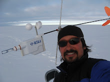
 The sensor that attaches to the tether. Cups measure wind speed, the orange fins point the sonde in the wind's direction. The tip has a temperature and relative humidity probe. See how it is attached to the line.
 Never tethersonde while drinking a cold beverage. It doesn't make you warm.
For the more technically inclined, here is a plot of the data from the tethersonde. Height is in meters above ground level (m AGL). Enjoy!
1 comment:
that balloon is so cute. :)
Post a Comment